-40%
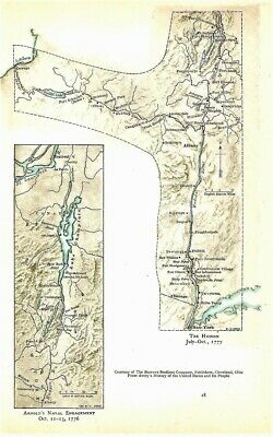
Antique 1776-77 Revolutionary War Maps The Hudson & Arnold's Naval Engagement
$ 6.33
- Description
- Size Guide
Description
Maps are original as published in 1911 and not photocopies.For sale here are 2 maps one one page,
one titled
ARNOLD'S NAVAL ENGAGEMENT Oct. 11 - 13, 1776,
and the 2nd titled
THE HUDSON July - Oct., 1777
.
Page accompanied a publication titled "The Revolutionary War and the Military Policy of the United States" which was published in 1911.
Some n
ames I see on maps include Ramapo, New York, Tarrytown, Haverstraw, Stony Point, Peekskill, Fort Montgomery, Fort Constitution, Continental Village, Fort Independence, Verplanck's Point, West Point, Fort Clinton, Dobbs Ferry, Poughkeepsie, Kingston, Catskill, Albany, Schoharie, Saratoga, Half Moon, Bemis Heights, Schaticook, Burgoyne Surrenders, Fort George, Fort Edward, Fort Miller, Fort Anne, Fort Ticonderoga, Mt. Defiance, Lake George, Skenesboro, Oswego, Oneida Lake, Fort Schuyler, Oriskany, Utica, German Flats, Mohawk River, Canajoharie, Fort Hunter, Schenectady, Amsterdam, Stillwater, Greenwich, Cambridge, Lake Champlain, South Bay, Crown Point, Split Rock Point, Where Arnold burned his boats, Valcour I., Cumberland Head, Montreal, Chambly, St. Lawrence River, French Mt., and more.
Page measures approx 5 5/8" by 8 3/4", pair of maps together approx 4 1/2" by 7 3/4" with blank back on lightweight paper. It is in excellent condition.
MAP IS MUCH SHARPER AND CLEARER IN REAL LIFE THAN IT IS IN MY BLURRY SCAN.
Satisfaction guaranteed, successful bidder to
prepay and include .50 for 1st class S & H in the US without a tracking number. Thank you.
Multiple similar items may be combined for a reduction in postage.
.
Track Page Views With
Auctiva's FREE Counter


